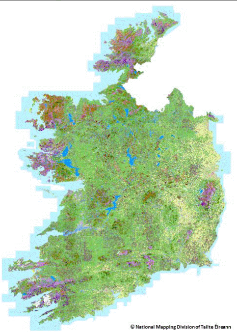
The EPA and Tailte Éireann (formally Ordnance Survey of Ireland) have launched a new National Land Cover Map of Ireland that categorises over 10 million landscape features for the first time.
The National Land Cover Map was produced by the National Mapping Division of Tailte Éireann (formerly OSI) in partnership with the Environmental Protection Agency (EPA). The aim of a land cover map is to map what is physically present on the Earth’s surface, for example forests, grasslands, and artificial areas. The map was created by combining existing land cover data with remote sensing methods, aerial and satellite images. The map includes very detailed information on land cover types in Ireland and marks a significant improvement in land evidence. It will have many uses in environmental assessments on water, climate, air, noise, and biodiversity and will be an important resource into the future.
A useful explanation of land cover is that it refers to what is physically present on the Earth’s surface. This includes surfaces like natural vegetation, freshwater and non-living surfaces. Grasslands, forest areas and artificial surfaces, are all examples of land cover types.
It is important to note that land cover is different from land use. Land use specifically refers to how that land is used or the activity at that location. Uses can be environmental, economic, or social and are usually a result of human intervention or management.
The Land Cover Map was produced based on 2018 data and is known as National Land Cover (NCL) 2018. It includes 36 different land cover classifications, all of which have been specifically defined to reflect the unique and diverse landscapes of Ireland. This information will help government agencies, public sector bodies and commercial organisations alike to focus on the environment and better understand the challenges posed by development, habitat loss and climate change.
‘The land cover map delivered by the Tailte Éireann and EPA will facilitate improved monitoring and assessment of the impacts and benefits for water, climate, air, noise and biodiversity, as well delivering support for better decision making on land management” said Laura Burke, Director General of the EPA.
The map is available at:
National Land Cover Map | Environmental Protection Agency (epa.ie)